BHUBANESWAR: Rain and wind lashed India's east coast and nearly 400,000 people fled to cyclone shelters after the government issued a red alert and warned of severe damage when one of the largest storms the country has ever seen makes landfall later on Saturday.
Muslims and Hindus gathered at mosques and temples in Odisha state, praying Cyclone Phailin would not be as devastating as a similar storm that killed 10,000 people 14 years ago. Heavy rain pounded coastal villages in neighbouring Andhra Pradesh.
Phailin was packing winds of at least 220 kmph (137 mph) on Saturday morning and was expected to cause a 3.4 metre (11-foot) surge in sea levels when it hits the coast in the evening, the India Meteorological Department said in a statement.
"The storm has high damage potential, considering windspeed,"Lakshman Singh Rathore, head of the weather department, said on Friday.
Families walked through the rain to shelters, television images showed, as gusts of wind snapped branches from trees. Tourists left popular beach resort Puri. Officials broadcast cyclone warnings through loudspeakers, radio and television.
"The wind speed is picking up," said Odisha's special relief commissioner, Pradeep Kumar Mohapatra. "Some people were earlier reluctant to move. They are willing now."
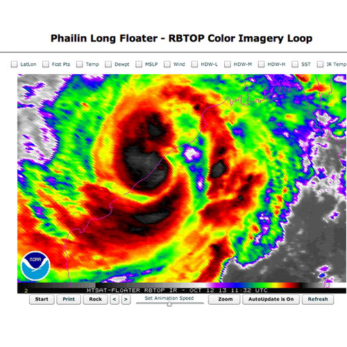
Filling most of the Bay of Bengal, Phailin was about 300 km offshore on Saturday morning,satellite images showed, and was expected to reach land by nightfall. Officials said the storm was verging on becoming a "super cyclone."
London-based Tropical Storm Risk said the storm was already in that category, and classed it as a Category 5 storm - the strongest. The US Navy's weather service said wind at sea was gusting at 314 kph.
Some forecasters likened its size and intensity to hurricane Katrina, which tore through the US Gulf coast and New Orleans in 2005.
Its scale also stirred memories of a 1999 Indian storm when winds reaching speeds of 300 kph battered Odisha for 30 hours.
This time, however, the Odisha government said it was better prepared. Half a million people are expected to shelter in schools and other strong buildings when the storm hits, officials said. At least 60,000 people left their homes in neighbouring Andhra Pradesh on Friday.
Authorities warned of extensive damage to crops, village dwellings and old buildings, as well as disruption of power, water and rail services. Shelters were being stocked with rations, and leave for government employees was cancelled.

A police official said a rescue effort was launched for 18 fishermen stranded four nautical miles at sea from Paradip, a major port in Odisha, after their trawler ran out of fuel.
Paradip halted cargo operations on Friday. All vessels were ordered to leave the port, which handles coal, crude oil and iron ore. An oil tanker holding about 2 million barrels of oil, worth $220 million, was also moved, an oil company source said.
But the storm was not expected to hit India's largest gas field, the D6 natural gas block in theCauvery basin further down the east coast, said Reliance Industries, which operates the field.
Katrina hit the US Gulf coast on August 29, 2005, killing about 1,800 people, including many in New Orleans where levees failed to hold back storm surges.
It was one of the six biggest hurricanes - also known as cyclones and typhoons - ever recorded and caused damage of around $75 billion.
Muslims and Hindus gathered at mosques and temples in Odisha state, praying Cyclone Phailin would not be as devastating as a similar storm that killed 10,000 people 14 years ago. Heavy rain pounded coastal villages in neighbouring Andhra Pradesh.
Phailin was packing winds of at least 220 kmph (137 mph) on Saturday morning and was expected to cause a 3.4 metre (11-foot) surge in sea levels when it hits the coast in the evening, the India Meteorological Department said in a statement.
"The storm has high damage potential, considering windspeed,"Lakshman Singh Rathore, head of the weather department, said on Friday.
Families walked through the rain to shelters, television images showed, as gusts of wind snapped branches from trees. Tourists left popular beach resort Puri. Officials broadcast cyclone warnings through loudspeakers, radio and television.
"The wind speed is picking up," said Odisha's special relief commissioner, Pradeep Kumar Mohapatra. "Some people were earlier reluctant to move. They are willing now."
Filling most of the Bay of Bengal, Phailin was about 300 km offshore on Saturday morning,satellite images showed, and was expected to reach land by nightfall. Officials said the storm was verging on becoming a "super cyclone."
London-based Tropical Storm Risk said the storm was already in that category, and classed it as a Category 5 storm - the strongest. The US Navy's weather service said wind at sea was gusting at 314 kph.
Some forecasters likened its size and intensity to hurricane Katrina, which tore through the US Gulf coast and New Orleans in 2005.
Its scale also stirred memories of a 1999 Indian storm when winds reaching speeds of 300 kph battered Odisha for 30 hours.
This time, however, the Odisha government said it was better prepared. Half a million people are expected to shelter in schools and other strong buildings when the storm hits, officials said. At least 60,000 people left their homes in neighbouring Andhra Pradesh on Friday.
Authorities warned of extensive damage to crops, village dwellings and old buildings, as well as disruption of power, water and rail services. Shelters were being stocked with rations, and leave for government employees was cancelled.
A police official said a rescue effort was launched for 18 fishermen stranded four nautical miles at sea from Paradip, a major port in Odisha, after their trawler ran out of fuel.
Paradip halted cargo operations on Friday. All vessels were ordered to leave the port, which handles coal, crude oil and iron ore. An oil tanker holding about 2 million barrels of oil, worth $220 million, was also moved, an oil company source said.
But the storm was not expected to hit India's largest gas field, the D6 natural gas block in theCauvery basin further down the east coast, said Reliance Industries, which operates the field.
Katrina hit the US Gulf coast on August 29, 2005, killing about 1,800 people, including many in New Orleans where levees failed to hold back storm surges.
It was one of the six biggest hurricanes - also known as cyclones and typhoons - ever recorded and caused damage of around $75 billion.